Cycling along the canals was easy going through pleasant countryside and I arrived at Milngavie, the start of "The Way" around 6.30. I bivied at the end of Mugdock Woods about 20 minutes cycle from the start.
Highlite of the day was seeing a wild mink which came to within 3 metres of me whilst I was stopped.
I awoke to the call of a lone female red deer, a very strange noise much like a bark. The weather was looking good.
The push, due to steepness and erosion, up the last part of Conic Hill is worth it for the views out over Loch Lomond.
Loch Lomond from Conic Hill.
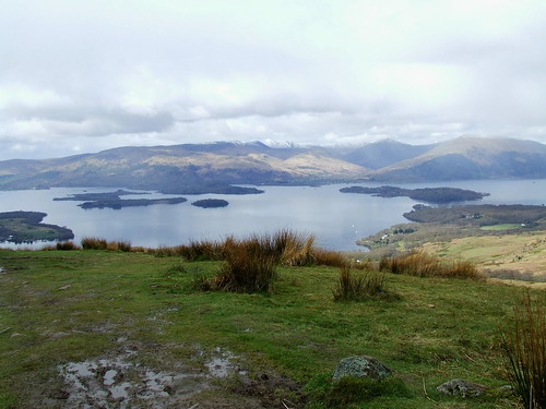
2012_0414westhighlandway0003 by youngray50, on Flickr
The North East end of Loch Lomond was a nightmare due to the terrain. I pushed, dragged, lifted, carried and even scrambled on two occasions for 3 1/2 hours. I gave up trying to cycle early on due to the frequency of unrideable obstacles.
I arrived at Doune bothy at 7PM and after heavy and cold rain for the last 1/2 hour and the fact that my shoulders were killing me it was a lovely sight to behold. I spent a very pleasant evening with Martin and Jim, 2 Glaswegians and Chris, an American.
Doune bothy in the morning.

2012_0414westhighlandway0008 by youngray50, on Flickr
Next day I did very few miles due to tiredness from my exertions the day before and the pain in my shoulders, I only made it to Tyndrum before calling it a day.
The military road above Crianlarich looking towards Ben More and Glen Dochart.

2012_0414westhighlandway0009 by youngray50, on Flickr
My Tyndrum bivi in "the wettest woods in the world".

2012_0414westhighlandway0010 by youngray50, on Flickr
This bivi spot took a 1/2 hour to find due to the 5cm deep moisture laden moss that carpeted the woodland floor.
Weather wise looking like another great day with Rannoch Moor and the descent off The Devil's Staircase to look forward to.
The climb onto Rannoch Moor.

2012_0414westhighlandway0012 by youngray50, on Flickr
Rannoch Moor looking east to the Grampians.

2012_0414westhighlandway0011 by youngray50, on Flickr
The going on Rannoch Moor was easy with a lovely descent off the top, however, the weather threw 20 minutes worth of heavy hail at me as I neared the high point.
Rannoch Moor in the hail.

2012_0414westhighlandway0014 by youngray50, on Flickr
I had a rest before the push up The Devil's Staircase which is not as bad as it sounds.
Top of The Devil's Staircase looking over Glen Coe to Stob Dearg. The group are Manchester Geology students on a 10 day field trip.

2012_0414westhighlandway0015 by youngray50, on Flickr
The descent off the top to Kinlochleven was great with many a rock garden to contend with. Near the bottom of the technical stuff I had a bad spill, hitting my head hard on the ground but luckily missing a big boulder. I was dazed for about 5 minutes and sat recovering for anotherb 10. I set off at a more sedate pace and on arriving at Kinlochleven decided to call it a day despite only 15 miles to go, I was still feeling a bit wobbly after the crash and decided to play it safe.
Kinlochleven bivi with me "n" tinnie.

2012_0414westhighlandway0017 by youngray50, on Flickr
Same bivi looking west to Sgorr Dhearg behind the tree.

2012_0414westhighlandway0018 by youngray50, on Flickr
The weather was great on the last day but it started with a 20 minute push up an eroded path to a landrover track.
At the top of the pushwith Bein Na Caillich in the foreground.

2012_0414westhighlandway0020 by youngray50, on Flickr
The same spot looking in the direction of travel.

2012_0414westhighlandway0019 by youngray50, on Flickr
The rest of the going was easy with the occasional techy bit thrown in followed by an easy descent through woods to the road leading to Fort William.
All in all a great ride but if your tempted then get the ferry past the north east part of Loch Lomond. South/North is the best direction of travel to get the best descents. Technical bits are dominated by paths with both loose and buried rocks and boulders, rock gardens and paths eroded down to the bedrock.
I am no longer a bivi virgin but feel I am still to be baptised by setting up and sleeping under a tarp in the rain.