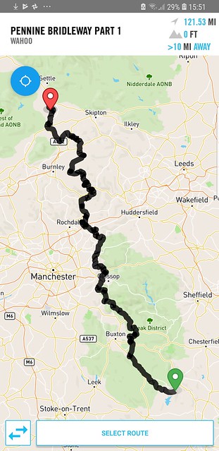
Anyone fancy a hundred (or 120) miler from Wirksworth (Matlock) to Wigglesworth?? Bivi at the halfway points or something or when the legs cannot go any farther??
Preferably a non-smoking anyone (I get tempted and took me a near death experience to finally quit which I still almost failed on)
Shafiq
NB. I will most likely be slower than most of you guys so I guess you could end up sorting the craving whilst awaiting atop the climbs!!
Last edited by redefined_cycles on Mon Feb 25, 2019 6:57 pm, edited 1 time in total.
excellent... I didn't wanna state non-drinker and make a big deal of it all. Thats double whammy nice. I was thinking to make it a BAM for Feb and MArch. But the 1st is a Friday for which I would prefer being home for, for firday prayers... Lets discuss and arrange... am flexi and now that I have my framebag (honestyl the fear of the cold wasnt stopping me ) I wanna get on this PBW and maybe one day do the whole lot... Thats one of the reasons why I registered anyways...
A quick heads up: the PBW between Weets (the hill just after Barnoldswick) and Long Preston is tedious, prone to being boggy and somewhat overgrown, not even the horse crowd seem to use it. Best to use the lanes that it weaves in and out of.
Better weight than wisdom, a traveller cannot carry
Thanks for the heads up Bob. Did you get that @lazarus as we (me and you) will hold you personally responsible if we end up knee deep in some bog...
Erm dates... ok. Weekend. How about the weekend after?? (Will confirm with the home office that I'm allowed out without an earful... or will I have to take the earful and go
Dont know about the southern part of the route, but if conditions are good, then there are quite a few alternatives which would make the route a lot better, between Uppermill and Settle.
Chew wrote:Dont know about the southern part of the route, but if conditions are good, then there are quite a few alternatives which would make the route a lot better, between Uppermill and Settle.
Please do share Chew... or is it just a matter of looking at an OS map with the obvious long green lines (ie. are these exciting lines easy to find on the OS)
You'll be fine staying on the PBW past Uppermill as far as the road bit north of Widdop (here) - that's alll riding fine. Haven't been past that for a while though. It's good trails through that stretch too imo.
It’s fine from Widdop through Wycoller and down to Earby. Might be muddy into and out of Earby. Fine from Barlick up on to Weets and down from there. Silly loops through fields to avoid Gisburn
Better weight than wisdom, a traveller cannot carry
Ground conditions need to be good as certain parts can be a bit boggy. I wouldn’t do it on a sunny bank holiday, but…
From Uppermill follow the PBW up through Diggle and up to the carpark near to the top of Standedge.
From there theres a track that follows the ridge, taking you across the A640, White Hill, over the M62 to Blackstone edge.
A bit of bike-a-hike, over Blackstone edge but nothing too bad.
Then across to the White Horse Pub, and follow the ridgeline past the reservoirs making your way across to Stoodley Pike
This way you get to keep most of the height, before dropping down into Hebden.
(various options depending on what you’re looking for)
From Hebden theres a nice bridleway that takes you up to Jack Bridge. From there pick up the PBW to Egypt (yes really) and then down past the reservoir and on the road past Widdop.
Follow that road to the high point at 389m and then follow the track NE up to Lad Law.
Again this will keep your height and is great, with a slight push here and there.
From the top there are some great sheep tracks, so just follow your nose to join the main track that leads to Brink Ends, and follow the Pendle Way, down in to Wycoller.
It’s a great little place with a nice café.
Pick up the lanes to Foulridge, where you can jump on the canal to East Marton, follow the track to Stainton Hall, and then another track to Coniston Cold.
Roads through Bell Busk and Otterburn, and then the track NW to Settle
Just an update on this... me and Johnnie decided to get the train from Rochdale and go north by around 60 to 0 miles... then ride back down to Rochdale and jump in cars and home. Meeting up at Long Preston at roughly 10 to 11am and riding the PBW South back to Rochdale...
Feel free to throw in your thoughts as I know I mighy noy have managed to take account of what was said before about Barnodlswick as it was a quick drawing using the OS map and PBW overlay. Clitheroe to Rochdale but willl play it by ear on the day... maybe someone else might join
Don't think we've met Mike. Shafiq (AbuUzair which just means Uzairs dad on strava) from Hudderfield/Dewsbury. One one the softer forum members you could say (but I do smile alot and say hello and my bike is called Stan*).
So far its just me and @lazarus (Johnnie from the Chorley sides of play)
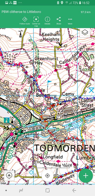
I'd stay on the PBW instead of turning off at 59km like you've done there. The road NE of Hebden Bridge that the PBW drops onto is a lot more quiet and pleasant than the one your route follows. Your route also goes through a bit of a shitty bog before your descent into Todmorden.
Me and Johnnie are pretty Shitty-bog-ophobic to be fair... so if we avoid Hole Bottom I assume it avoids shitty bog
Regards the section where Bob talked of north of Barnodlswick, I think we have already missed it by actually coming to Barnodlswick from Clitheroe which is to the West, right??
Some of the sections on the strava not accurate cos whrn you import from gpx as a route it cannot believe there is tracks in certain areas...
Route planning is ongoing and we will edit accordingly or just consider the advice when out there riding (you got all the advicd right Johhny ).. will edit later to remove any other boggy sections. Thanks for your wonderful advisories all...