Page 1 of 1
Could you give my route the once over please?
Posted: Tue Oct 22, 2013 5:10 pm
by composite
So I'm trying to put together a route for a day ride that takes in the best bits of the North section of the Bearbones route, but starting from Rhayder. As I did most of North of strata florida in the dark I would like to take it in during the day. :)
The route I have planned is here:
http://www.bikehike.co.uk/mapview.php?l ... er_res.gpx (riding clock wise)
It also uses some bits of the EWE and the trans-cambrian and the WC2C. I have deliberately tried to avoid any of the nasty sections there were on the BB200. This is meant as a cruise not a personal challenge.

So to those that know the area:
Have I included any of those hike a bike bits by accident?
Are there any bits I have done that you would say don't bother with?
Any bits that could be re-routed to include some "RAD TRAIL BRO!" that I wouldn't know about from the map? 8-)
Re: Could you give my route the once over please?
Posted: Tue Oct 22, 2013 5:40 pm
by Bearbonesnorm
Okay, 3 things I can see:
As it stands it would work better anti-clockwise, that's mainly due to the really steep chute that joins the wind farm at Cripiau Nantmelyn to the valley bottom ... going up is a death march.
Secondly, if you do decide to ride it clockwise don't take the right fork on the road to Pont Elan. Instead, stay on the road for another couple of km then pick up the track (on the left) marked Penrhiw-wen on the map and drop down to the start/finish via that ... you'll like that bit.
And lastly ... what do you mean 'nasty sections'?

Re: Could you give my route the once over please?
Posted: Tue Oct 22, 2013 6:21 pm
by Ian
Penrhiw-wen - known locally as the Golf Links (though no idea why). Best descent in the area by a good length.
Some of that route could be a useful recce for the gravel race too
Re: Could you give my route the once over please?
Posted: Tue Oct 22, 2013 6:39 pm
by nostoc
The chute bit that is most popular, if you like that sort of thing, is the bridleway from 807805 down to 797796 (only skirting round the back of the clearing at Blaen Myherin at the bottom). Steep and loose with silly-steep alternatives.Like Stu says, anticlockwise only.
Personally I would stick to the high ground by turning south at Cripiau Nantmelyn and heading direct to the Arch
Or better, ride it clockwise, leave the Arch road at 776750, bear right and take the zigzag climb up Banc Myherin crossing close to the summit of Pen y Garn and descending to Cripiau Nantmelyn. One of my favourite climbs that no-one else seems to do. Then you could take up Stu's suggestion of the descent into Rhyader.
Re: Could you give my route the once over please?
Posted: Tue Oct 22, 2013 7:53 pm
by chris n
Ian wrote:Penrhiw-wen - known locally as the Golf Links (though no idea why). Best descent in the area by a good length.
Exactly as it sounds - used to be a golf course up until the 60's. Very good descent.
Re: Could you give my route the once over please?
Posted: Tue Oct 22, 2013 8:47 pm
by Ian
Right, that would make sense. Always puzzled me, but not to the extent that I'd go and find the definitive answer...
Re: Could you give my route the once over please?
Posted: Wed Oct 23, 2013 11:25 am
by composite
Thanks for all the feedback people that's great. One more question and I'll go ride it.
So I've made a Anti Clockwise version taking in the steep chute off the wind farm.
http://www.bikehike.co.uk/mapview.php?l ... ckwise.gpx
A clockwise one that adds in the descent in Rhayder and climbs to the wind farm via the winding fire road.
http://www.bikehike.co.uk/mapview.php?l ... ckwise.gpx
I also made another clockwise version that puts the 3 reservoirs west of Rhayder back in. I wanted to see these in the day light and with the edits I made the clockwise direction lost about 10miles. I wondered what people thought of the bit I have marked between 909662 and 906644. It's basically a footpath which I wouldn't normally go out of my way to ride on but I can't really see another way to get back round that side of the water.
http://www.bikehike.co.uk/mapview.php?l ... rsion2.gpx
Re: Could you give my route the once over please?
Posted: Wed Oct 23, 2013 12:45 pm
by Ian
For the last option, I'd be inclined to go up the mountain road from Rhayader, over Roman Camp via the northern route (the descent down to Craig Coch is a real blast), and then tootle down through the dams.
I'd probably not bother with the track S of Afon Claerwen, unless you have a burning desire to get soaking wet feet.
When are you doing this ride?
If you don't mind company, I'd be up for joining you.
If you'd rather fly solo, that's cool too :)
Re: Could you give my route the once over please?
Posted: Wed Oct 23, 2013 1:23 pm
by Taylor
I'm liking the idea of riding this too, also without the wet feet bit.
Re: Could you give my route the once over please?
Posted: Wed Oct 23, 2013 3:30 pm
by composite
OK well I'm looking to ride this on Saturday November 9th maybe a 9:30-10am start. I'll be driving down from Birmingham then going on to Newport afterwards.
Every one is welcome to join in. It will be nice to have people to ride with on a ride over 20miles. My mates say I do to many unsociable distances now... *sniff sniff*
Latest version:
http://www.bikehike.co.uk/mapview.php?l ... ise_v3.gpx
What is the alternative if that track at Afon Claerwen is going to be under water?
Re: Could you give my route the once over please?
Posted: Wed Oct 23, 2013 4:53 pm
by Ian
composite wrote:What is the alternative if that track at Afon Claerwen is going to be under water?
You've seen there's a road on the opposite side of the river, right?
edit: 9th Nov. is good for me I think. cheers.
Re: Could you give my route the once over please?
Posted: Wed Oct 23, 2013 5:36 pm
by Bearbonesnorm
Gutted ... working :(
Re: Could you give my route the once over please?
Posted: Wed Oct 23, 2013 5:54 pm
by composite
Are we talking about this bit?
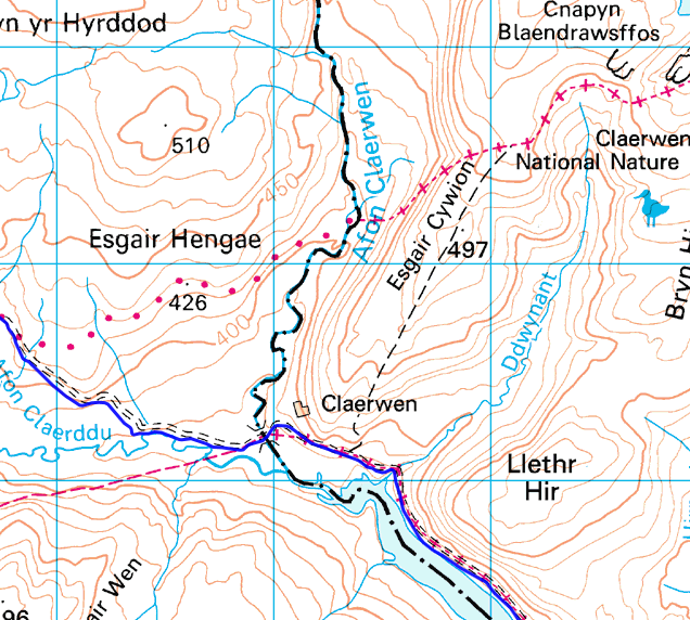
I guess it doesn't matter quite so much if you are coming along... local knowledge and all that. I'll just follow you... which I'm sure will being happening anyway although it might better be described as trying to keep up.
Re: Could you give my route the once over please?
Posted: Wed Oct 23, 2013 6:17 pm
by Ian
I meant the byway on approach to the Dam.
Re: Could you give my route the once over please?
Posted: Wed Oct 23, 2013 10:07 pm
by composite
Fingers crossed this is the final version.
http://www.bikehike.co.uk/mapview.php?l ... ise_v5.gpx
I'll make a post in the playing out forum closer to the date.
Re: Could you give my route the once over please?
Posted: Thu Oct 24, 2013 4:00 pm
by ericrobo
Are there any good places to leave a car for a few days in Rhayader ? Or in Elan ?
Interested in exploring this area a bit more. Done a 20 miles route there a few years back, just for the day.
Re: Could you give my route the once over please?
Posted: Thu Oct 24, 2013 4:27 pm
by Ian
Free parking for about a dozen cars at SN 965678. Never had any problems there, even with an overnighter.
http://goo.gl/maps/LR3bf