and losing motivation for BAM
so decided to go to Cross Fell, 85 mile drive, set off Monday morning after 11 and parked in Dufton, and set off at 1:15 heading for Milburn... 5 miles of very quiet road, met two cyclists, one tractor who gave me a wave, and no other vehicles
Finding the BW from Milburn was a bit tricky, but found it and got going.
A marked track which a tractor had been on, rideable for 5 minutes then it started going up, still rideable but soon had to push.
Then left the tractor tracks and pushed through a field to a BW sign at the end, then pushed again, riding a bit, then pushing a bit, through another field. going upwards now, and the tussocks were starting.
BW sign in the corner of the field where there was a pond
so a bit of a balancing act to get through that one.
Then tussocks chest high... no sign of any BW
Grim to say the least, but kept checking my line on the map, and ever onward....
I was trying to reach Silverband Mine (at about 2200 feet) from where there appeared to be a track going east and level.
It took me about 3 hours of pushing through tussocks and sphagnum moss and all the usual tundra vegetation.
But the sun was out
It looks lovely on the map when you see these lovely red lines in what looks like good remote country, but tbh I half expected this...
It must have been over 1700 feet of mainly pushing from Milburn to Silverband mine, No trace of a BW except a few hundred feet at the start.
When I reached the track at the mine, it had gone 5pm and I was getting worried that my objective of getting the tent up before dark might not happen.
But after about half a mile at Green Castle the track met a road ! Actually it's a BW !! And it's supposed to be the highest road in Britain, tarmacked to get to the Civil Aviation Radar Station on top at just short of 2800 feet.
So I found a spot and got the tent up, and got my meals in and a brew and was in bed for 7:30PM.
With 5 layers on !
It was zero degrees.
 2019-10-21 17.53.04 by Eric Robinson, on Flickr
I peeped out a bit later and it was a magnifcent starry night, but later on the wind got going and it was very strong.
I was fairly comfortable despite all the blowing (it's a Zpacks Hexemid, so it lets a lot of air in, but only 10 ozs (about 300 grams)
Up when it was light at about 7:30am and the wind was very strong and there was a thick mist too.
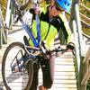
 2019-10-22 08.43.57 by Eric Robinson, on Flickr
My original plan was to get to the top, and head over to Cross Fell, and take a track to Garrigill, then head back south on a small road and some cheeky, to get the track leading past High Cup Nick, and back to Dufton.
After all the pushing on Monday I decided just to get to the top, and weigh up options fron there.
So I packed up and started up the BW of a road... spectacular... and steep !
I managed to ride it all helped by the wind !
On top at the radar station it looked like more pushing to get to Cross Fell, and I'd had enough of that, and it was very misty, so I decided to go downhill about 8 miles to Dufton.
I had to descend quite slowly because of the wind, which I was now going into.
I stopped at one point to check my handlebar or wheel wasn't loose. A horrible front wheel wobble caused by the wind.
Cold hands and feet since breakfast, all the way up and down.
Found a cafe on Orton, then set off home.
There are only a few BWs in these parts, but the on from Milburn is to be avoided
I remember years ago going up to High Cup Nick, and it was ok..