Page 13 of 32
Re: HT550 - 2017
Posted: Thu May 11, 2017 11:47 am
by touch
That's what I thought initially too. It looks like the track has stopped at Melgarve bothy but looking further back it wasnt an overnight stop. It was 9:30 am yesterday morning when it stopped.
He did use the message button to say "everything is ok" a few mins before he stopped.
Re: HT550 - 2017
Posted: Wed May 17, 2017 8:03 pm
by Ben98
Does anyone know the longest distance between resupply off the top of their head?
And also, to save me rooting through emails, are we going clockwise or anti?
As you can tell I'm well prepared with less than 2 weeks to go

Re: HT550 - 2017
Posted: Wed May 17, 2017 8:27 pm
by slarge
Ben, we're going anticlockwise. Follow the "out" route first then the "back" route.
For resupply its probably from Ullapool to Kinlochewe, thats big in both time and distance. My approach is to carry food for a day and replenish when you can.
Re: HT550 - 2017
Posted: Wed May 17, 2017 8:28 pm
by ScotRoutes
Contin to Drumbeg is probably the most problematic. Small shops, limited opening hours. There are a couple of hotels en route that might be an option if your timing is correct.
Re: HT550 - 2017
Posted: Wed May 17, 2017 8:49 pm
by whitestone
Ben, have a read of the thread from last year -
http://bearbonesbikepacking.co.uk/phpBB ... f=7&t=7738
After the stores at Contin there's the Oykel Bridge Hotel, Kylesku Hotel, Drumbeg Stores, Lochinver (Pie shop, stores, pubs), Oykel Bridge Hotel, Ullapool, Kinlochewe, Dornie, Tomich, Fort Augustus, Fort William, Kinlochleven. Some of the above are very small places - the Oykel Bridge Hotel is basically all that's there for example. With a very low population, opening hours of shops tends to be "traditional". As Colin says: timing is crucial.
Have a look at last year's Trackleaders; find someone who finished in about your intended pace and see when they passed the above points, it should give you a good idea of timing and if you need to push on or take it easy to make sure you are there when the shop/cafe/pub are open.
Re: HT550 - 2017
Posted: Wed May 17, 2017 8:54 pm
by fatbikephil
Contin to Drumbeg is about 120 miles and say around 20-24hrs of riding plus stops. There is the Oykel Bridge hotel around 45 miles after Contin which as per Alans email does good food. You'll also get sandwiches and crisps etc to take away.
Ullapool to Kinlochewe is a mere 40 odd miles but this will take around 11 to 15 hours....
Re: HT550 - 2017
Posted: Wed May 17, 2017 9:15 pm
by ianfitz
Ben98 wrote:Does anyone know the longest distance between resupply off the top of their head?
And also, to save me rooting through emails, are we going clockwise or anti?
As you can tell I'm well prepared with less than 2 weeks to go
As others have said - it's not the distance between them: it's how long it'll take to travel between them
Like steve I aimed to carry a days worth of food and didn't pass up the opportunity to eat hot food if it was available. I had venison chilli and rice at the OBH and then burger, chips and a tesco trip in Ullapool 3 hours later!
Re: HT550 - 2017
Posted: Wed May 17, 2017 9:54 pm
by Mariner
touch wrote:
That's what I thought initially too. It looks like the track has stopped at Melgarve bothy but looking further back it wasnt an overnight stop. It was 9:30 am yesterday morning when it stopped.
He did use the message button to say "everything is ok" a few mins before he stopped.
For some reason the SPOT decided to jack it in before I did.
As we are talking strategies here is what I learned.
Carry more water. I had .75l bottle which meant lots of re filling. Loads of water at low level very little once you climb up higher or very little that you would want to drink plus drank all the water getting to higher level.
Really work out your food strategy. I went light and ended up having to get over the Corrieyairack on half a squashed Tuna Mayo sandwich and a lukewarm cup of coffee because Wolftrax wasn’t open when it was supposed to be in the morning.
M&Ms are rubbish for breakfast but strangely Marathon bites work but there comes a point when anything will do.
I took a big down bag and tent as opposed to quilt and tarp and got caught out yet again by evening descent into a deep glen. Fast with not much effort in light clothing into a frost hollow meant suddenly too cold to continue. Don’t underestimate the effect of altitude/temperature changes.
Plan was Melgarve first night into Invermoriston 0800 for breakfast at the hotel but only made Fort Augustus at 1200 totally bonked.
Felt rubbish called it a day apart from having to ride down to Fort William.
Not my finest hour but would not have missed it for anything.
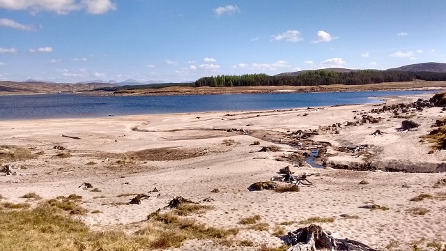 IMG_20170509_162132090_HDR-1 (640x360)
 by
michaelandamanda, on Flickr
Tides out Loch Ericht
Re: HT550 - 2017
Posted: Wed May 17, 2017 11:05 pm
by Howard
Mariner wrote: but would not have missed it for anything.
You were out there, enjoyed it, and came back safe. That's the main thing

Re: HT550 - 2017
Posted: Thu May 18, 2017 9:34 am
by Mariner
Howard wrote:Mariner wrote: but would not have missed it for anything.
You were out there, enjoyed it, and came back safe. That's the main thing
OOOOOOOOH salt in the wound!
It was your schedule I was using and couldn't match

Re: HT550 - 2017
Posted: Thu May 18, 2017 1:36 pm
by Bert
Anybody know where I should locate Duchally Lodge, with the locked gate? It's supposed to be in the northern loop, but I can't locate it on the map.
Re: HT550 - 2017
Posted: Thu May 18, 2017 1:37 pm
by touch
It's in Glen Cassley, north of Rosehall.
https://binged.it/2pX59KU
Re: HT550 - 2017
Posted: Thu May 18, 2017 1:44 pm
by whitestone
Bert wrote:Anybody know where I should locate Duchally Lodge, with the locked gate? It's supposed to be in the northern loop, but I can't locate it on the map.
The locked gate is here
http://streetmap.co.uk/map.srf?X=238911 ... &A=Y&Z=115 to avoid it, take the track to the left then at the river cross the small stream on your right and follow the path between the river and the fence. Don't follow the fence from the gate - there's a very nasty swamp!
Re: HT550 - 2017
Posted: Thu May 18, 2017 2:00 pm
by whitestone
A question aimed at Greg but no doubt someone else may know:
I've linked my SPOT and Twitter accounts so that the messages get posted across. Should the message include @ht_550 and #HT550 so that you pick them up?
Re: HT550 - 2017
Posted: Thu May 18, 2017 4:55 pm
by Neil Beltchenko
Hey Friends,
I'm coming over from the States to race next week, sooooo very excited!
I've been reading through all the comments on this thread and it is very helpful, so thank you all for that.
I'm currently going through the map, looking a resupply locations. Before I dig too deep, I would like to download a GPS TOPO map to give me some ideas of terrain. That being said, what GPS base maps are people using? I typically get free maps from GPSFileDepot.com, but it appears the maps are not that great. I would rather not pay, but will if I have to.
Also, I fly in on the 24th at 7am into Glasgow, I'm trying to hook up with some folks if anyone is around. I may grab a hotel room but I would like to stay up to get used to the time change. I would also love to save some money on the front end of the trip, if anyone has some extra room in there homes, that would be vaguely exciting! Totally understand if not, I'm just bracing for an expensive 12 days.
Edit: Also, looking at the first 100 miles, man, thats a lot of road. I have been training with some big knob tires specifically for this race, now I'm considering going with a fast roller, any thoughts on that?
My email is Neil.beltchenko@gmail if anyone wants to contact me.
Best,
Neil
Re: HT550 - 2017
Posted: Thu May 18, 2017 5:34 pm
by Chew
Neil Beltchenko wrote:That being said, what GPS base maps are people using? I typically get free maps from GPSFileDepot.com, but it appears the maps are not that great.
Drop Dave Barter an email
Re: HT550 - 2017
Posted: Thu May 18, 2017 5:54 pm
by fatbikephil
Use Ordnance Survey - anything else is a poor substitute and not accurate enough for the terrain the route crosses. 1:50k will be fine. Buy from
https://www.ioffer.com/i/gb-discoverer- ... =296337950 Never quite worked out how dodgy this site is but I know several people who've bought Garmin OS map cards from them and they work fine. I sprung for the OS premium which includes 1:25k - this is super accurate and covers pretty much every terrain feature you will encounter.
A re-supply update - It appears that the garage / Londis supermarket in Fort Augustus is now open until 9pm. Unfortunately it looks like the Tesco in ullapool now doesn't open until 8am instead of 7am as previous. The wee petrol station on the way out of Ullapool opens at 7.30am.
Re: HT550 - 2017
Posted: Thu May 18, 2017 6:05 pm
by Ian
There's very little "road" in the first section. By road, we usually refer to tarmac / asphalt / black top (whatever you guys call it!). Plenty of gravelled track, but not all of it that smooth - 2.2" Ikons ftw

Good luck, Neil - your attendance should add an extra element of interest to the dot watching
Re: HT550 - 2017
Posted: Thu May 18, 2017 6:35 pm
by ianfitz
I use Dave Barters maps (I'll email you his details) which I find as good as the OS ones for detail. They're free too.
There's a great website bikehike.co.uk that you can import the route gpx to and then look at OS maps and Google Earth images to get a good idea of terrain. I've got pdf maps that will print on to normal printer paper if you want to carry paper back ups. I tweeted you about that but will include the link when I email.
I can't help with accommodation but will be passing through Glasgow on Friday midmorning if you're still there and would like a lift.
Re: HT550 - 2017
Posted: Thu May 18, 2017 6:42 pm
by whitestone
What we call "road" is called "pavement" in the USA, "pavement" in the UK is "sidewalk".
I use the maps from Dave Barter, they are fine, not as good as the OS but more than good enough. There's not a lot of roads/pavement, tracks or trails and once you start on a trail you are going to be on it for a while before the next junction.
If you are considering heading up to Tyndrum early then if you plan on going by train you will need to pre-book your bike as there's limited spaces available. Not sure if you can do that from outside the UK.
Re: HT550 - 2017
Posted: Thu May 18, 2017 6:46 pm
by ianfitz
Also yes the first half is quick riding. In some beautiful places though.
Time wise halfway is probably close to the second visit to the Oykel bridge Hotel
Re: HT550 - 2017
Posted: Thu May 18, 2017 7:27 pm
by touch
By my reckoning, 31.8% of the route (by distance) is road.
Re: HT550 - 2017
Posted: Thu May 18, 2017 7:29 pm
by JMich
Can anyone give advice on nightime temps... Is there a big difference in temp from low laying towns to 1000 ft? Trying to decide between a 0C and -10C bag (both with bivy and tarp).
I was also hoping someone could comment on the weather thursday or friday before the race. I'll be checking weather but it's nice to get a locals take on it. Thanks.
Re: HT550 - 2017
Posted: Thu May 18, 2017 7:36 pm
by Javi
I'd say 0c is fine, like the one I'm using.
Re: HT550 - 2017
Posted: Thu May 18, 2017 7:41 pm
by Richard G
Obvious I know... but just to be sure, there's a big difference between a 0c limit bag, and a 0c comfort (even bigger difference to extreme

)