
All my previous trips have planned using oS maps, and as they're walking trips I can use the map to navigate
I'd like to use my gps to navigate on the WRT (Garmin Oregon 550t)
What do people use to plan the route and import to the GPS?
I'm thinking about how the waypoints gets marked (which I've just done in Garmin Basecamp but the software is pretty poor, I have the 1:50k OS map), how you set the routes to follow all the right paths so you can use the GPS only etc
WRT route planning help
Moderators: Bearbonesnorm, Taylor, Chew
-
johnnystorm

- Posts: 4010
- Joined: Wed Nov 21, 2012 9:55 pm
- Location: Eastern (Anglia) Front
Re: WRT route planning help
Draw the route in Osgetamap online (and then convert to a gpx track in bikehike as osgetamap adds in loads of waypoints that scuppers the garmin) or in bikehike.co.uk itself.
A top tip is to scope out any potential bridleway/path/track on aerial photos as often what's on the map is invisible on the ground while a nice clear trail goes unmarked on the map!
Last time I did the WRT I chopped the route up into sections so if I wanted to drop a section it could easily be skipped without the whole route being abandoned.


-
rocklobstercat

- Posts: 128
- Joined: Fri May 03, 2013 4:57 pm
Re: WRT route planning help
I use a mixture of Where's the Path, Bing Maps (Ordnance Survey level), bikehike, Google maps (street level and ariel) and Geograph.org.uk.
Re: WRT route planning help
1) Mark all of the GR’s on a map (either paper or electronic). This will allow you to see the ‘shape’ and where you may want to head
2) From the ‘shape’ start to link the GR’s together. Some are close together and linking them is straight forward, others may take a bit of thinking about.
3) Roughly plot this initial route on something like bikehike.co.uk. If I plot a quick rough route (think one way point very 1km) i’d generally add on 10% to the suggested distance to take care of the squiggles.
4) Think what distance you may want to cover over the weekend. I generally work on a 10 kph total time on the bike (gentle pace, allows for gates, taking in the scenery, snack stops, etc...)
- Sat 5 Hours
- Sun 7 Hours
- Mon 3 Hours
- 15 Hours on the Bike = 150k route
5) Use google earth to check out your route. Just because a bridleway is on the map doesn’t mean it exists on the ground, and you may also find some other tracks which don’t appear on the map.
6) Dont fear the road. Pootling along quiet country lanes is quite nice so don’t try and cram in every last bit of off road for the sake of it.
7) The GR’s are there as a guide, so don’t feel the need to visit every one. I’ll be passing through a 1/3, going close to a 1/3 and ignoring the other 1/3 and i’ll still have a nice route (fingers crossed).
8) Think about contours and surfaces. One great decent is just a push in reverse.
9) Dont worry about finding the ‘perfect’ route. There isn’t one.
10) Plot for final route via bikehike and upload to your gps.
Re: WRT route planning help
Need to make one of team mates aware of this one.Chew wrote: 6) Dont fear the road. Pootling along quiet country lanes is quite nice so don’t try and cram in every last bit of off road for the sake of it.
-
Bigface0_0

- Posts: 165
- Joined: Wed Jun 22, 2011 1:00 pm
- Location: Sunny Southampton
- Contact:
Re: WRT route planning help
Need to make one of team mates aware of this one.
Thats not me... LOL BRING ON THE ROAD!!!!
BIKE RACING IS LIKE HAVING A MULLET, BUSINESS UP THE FRONT, PARTY IN THE BACK…!!!
Re: WRT route planning help
Chew, that's really helpful, thanks a lot
The GRs are plotted on 4 paper OS maps, as well as in Garmin Basecamp and Google Maps so I can see the shape of them.
Some questions:
Do you put all the GRs into bikehike at the start or just do it section by section?
Does bikehike give you a track or a route to put into your gps? (I think I want a track to made following it easier...?
-
Cheeky Monkey

- Posts: 3918
- Joined: Mon Aug 01, 2011 1:48 pm
- Location: Leeds ish
- Contact:
Re: WRT route planning help
Anyone wanting paper maps could try dash4it.co.uk and use code OS40 for a discount. Explorer Sheets 214 and 215, laminated was c.£16 delivered.
Re: WRT route planning help
Also, how do you actually put grid refs into bikehike?
Re: WRT route planning help
And vice versa, how do I know what grid ref I'm at in bikehike when hovering my cursor...?
-
Bearbonesnorm

- Posts: 24199
- Joined: Sun Jun 05, 2011 8:53 pm
- Location: my own little world
Re: WRT route planning help
I'm not sure you can* ... my way is to mark the GR on paper maps and devise a rough route between them. Then just copy that route over on Bikehike, save it as a gpx track and upload it onto the gps.Also, how do you actually put grid refs into bikehike?
*That should possibly say, I'm not sure I can.
May the bridges you burn light your way
Re: WRT route planning help
When you 'copy that route' does that mean you look for the most similar bit you can on bikehike (by scanning around as you can't search for it), and then do the closest approximation possible?
-
Bearbonesnorm
- Posts: 24199
- Joined: Sun Jun 05, 2011 8:53 pm
- Location: my own little world
Re: WRT route planning help
If you toggle the map sizes on bikehike and zoom in, it'll become 1:50k so you can just reproduce what's on your paper map onto the screen.When you 'copy that route' does that mean you look for the most similar bit you can on bikehike (by scanning around as you can't search for it), and then do the closest approximation possible?
May the bridges you burn light your way
Re: WRT route planning help
Great, thanks
So sounds like you have to 'faff', but the result is good
Shame there's no one solution that is easy and free!
So sounds like you have to 'faff', but the result is good
Shame there's no one solution that is easy and free!
-
rocklobstercat
- Posts: 128
- Joined: Fri May 03, 2013 4:57 pm
Re: WRT route planning help
You can put the grid references in Where's the Path. Click on the binoculars and enter the GR.
http://wtp2.appspot.com/wheresthepath.h ... n=-3.31208
http://wtp2.appspot.com/wheresthepath.h ... n=-3.31208
Re: WRT route planning help
rocklobstercat wrote:You can put the grid references in Where's the Path. Click on the binoculars and enter the GR.
http://wtp2.appspot.com/wheresthepath.h ... n=-3.31208
Yep thats where I started really easy,
click binoculars
enter GR
hit search
drop pin,
rinse repeat

Re: WRT route planning help
Here's a quick image of a similar method that Chew was talking about.
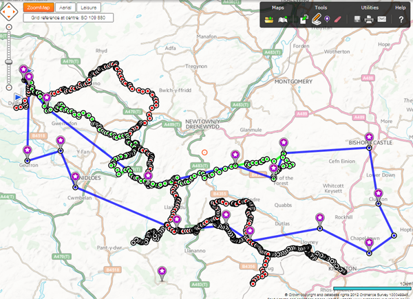
For this one I have used "OS Get a map" because its easy to enter a grid ref and then drop a marker. You can't do that on bikehike which is what I use when I plan a route without specific grid refs.
I have marked all the grid refs to start.
The blue line is a straight line between each to give me a visual reference of which direction I want I go when I'm zoomed in on the map.
The green, red, black lines are just bits of ideas and options. Eventually I would have enough options that a route will emerge from where the lines cross. :)
I also keep switching between the map view and the satellite view to make sure there is a track on the ground where there is one marked on the map.
If you think you need to use some country lane, then the lanes marked with the green dots are normally good ones to choose.
Re: WRT route planning help
Quick update to say thanks for everyone's help
Not finished but been using a combination of sites, mainly os getamap, and the route is coming along nicely. Passing through more GRs than planned, currently about 80 miles so happy with progress so far
Not finished but been using a combination of sites, mainly os getamap, and the route is coming along nicely. Passing through more GRs than planned, currently about 80 miles so happy with progress so far